|
|
Ettingshall |
|
|
Ettingshall is part of the 'Black Country'. Before the 18th century it was sparsely populated, dotted by small hamlets and farms and containing an abundance of forest, woodland, streams and ponds. There was a large Park - a home for the gentry of the area, but little else. During the the Industrial Revolution Ettingshall became heavily industrialised as a result of being there being abundant in coal deposits in the locality. Landowners became very wealthy as they exploited the natural resources on their land. Iron working and steel mills and their offshoot industries rapidly filled the area and workers flooded into the area from far afield. Existing hamlets suffered destruction as shafts built under them and burning coal seams caused buildings to collapse. Rapid intensive housebuilding resulted in densely packed housing developments - first houses followed the edge of road routes, allowing back garden space, but as demand increased back to back houses and courts of houses with no gardens were developed.
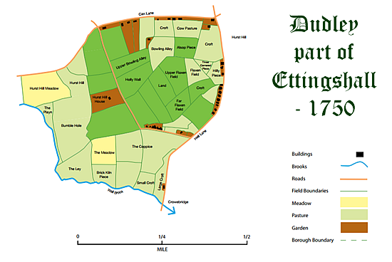
Ettingshall has over a thousand years of history attached to it. The place-name originates from the Anglo-Saxon language - pre-Norman conquest. The name comes from the personal masculine name 'Eatte', with the addition of 'ing' – meaning the descendants of - and 'hale' , meaning the corner or 'nook of land' where they live - so it means the dwelling of the 'Eatte' clan! The geology of the area is mixed: limestone in the west and coal deposits with fireclay in the east. This is what caused the area to be plundered in the 1800s. LocationEttingshall is an ancient settlement - it therefore straddles modernday boundaries - most of it now being within the Borough of Wolverhampton (of which Bilston is a part) and a small part of it is included within the Borough of Dudley - part of Ettingshall Park in the west, Hurst Hill and part of Highfields. This causes great problems when looking at the documents relating to ancestors who lived there. You will find documents registered at Rowley Regis, Dudley and Wolverhampton. Ettingshall will be called: Bilston, Sedgley, Coseley or Ettingshall - or the name of the small hamlets that were within the area. It is situated 1¼ miles to the south-east of Wolverhampton city centre and centred on the A4039 and A4126 roads. It is situated on the western edge of the former Borough of Bilston and began as an expansion of the Sedgley village of Ettingshall in the Victorian era, becoming part of the new Coseley Urban District Council in 1897. As the northern parts of the original Ettingshall extended across the border into Bilston, many new houses and factories were built and this area became known as "Ettingshall New Village", the Ettingshall that still exists in the present day. In 1966, the bulk of the old Ettingshall village was absorbed into the borough of Wolverhampton, along with parts of Brierley village, while most of the rest of Coseley - along Brierley Hill and the bulk of neighbouring Sedgley- was incorporated into an expanded Dudley borough. A few references to the original village in Sedgley still exist, with the Ettingshall Park Estate below the eastern slopes of Sedgley Beacon, while two roads in Coseley, Upper Ettingshall Road and Ettingshall Road still remain, their names reflecting the upper and lower parts of the extensive village. Ettingshall ward stretches between Wolverhampton city centre and Bilston, bordering the East Park, Bilston North, Bilston East, Spring Vale, Blakenhall and St Peter's wards. As well as Ettingshall, it covers the inner city area of All Saints. It forms part of the Wolverhampton South East constituency. HistoryEttingshall was first mentioned in an AD994 charter relating to a gift of Lady Wulfruna to the church of Hampton (Wolverhampton). By the days of the Domesday Book (1086) it had devolved to the Norman William Fitz-Ansculf. At that time a wood is mentioned as being part of the estate. That was probably was on the site of Ettingshall Park. The fact that it had originally been part of Wolverhampton's land was proven in a land transaction in 1261, when the Baron of Dudley paid to hold on to the management of Ettingshall Park by 'gifting' of several pounds of wax to St Peter's Church in Wolverhampton. Ettingshall Park was part of the Ettingshall area that was used as a park through the medieval period and, due to it being on a slope, has still not been developed. From the late 16th century the Gibbons family occupied the park. A Willielmus Gybbyns is recorded as holding it in 1588. This went to the Feredays in the 18th and 19th centuries. Samuel Fereday was a mason in the late 18th century in Upper Gornal. He sold freestone which was used for the beds of furnaces and died in 1796. His son Samuel became a farmer at Park Farm but eventually resided at Ettingshall Park and became one of the wealthiest owners of blast furnaces of his time. His son Dudley Fereday of Ettingshall Park was recorded as a 'gentleman' and died unmarried and Dudley's brother John rebuilt Ellowes Hall, in the early 19th century. Hurst HillHurst Hill is an Early English place-name meaning 'a wood on a bank'. By the late medieval period, the landscape of Hurst Hill included an oval shaped open field called Flaxen Field. This was surrounded by pasture land and an area bordering the Wall Brook called Bumble Hole. The Bumble Hole area was a site of early limestone mining activity. The earliest record of lime-working is in the reign of Elizabeth I. Documentary references refer to John Hall (1576) and Steyne Eyton (1601) as being `lyme-makers' and in 1614 Edward Hall is recorded as "holding a pasture called the Playne Hurst Fields conteyning by estimation 10 acres with the mynes called lyme pits." The limestone quarries still exist in the present Hurst Hill Wood. In a Survey of the Manor of Sedgley in 1614 John Pershouse of Walsall is said to have held Flaxalls as a tenement. The area he held seems to have been most of the Hurst Hill block including Lymepitt Leasowe next to the limestone workings. Only two cottages are recorded on the site in this document. It is probably the lime-workings that took the life of William Baker of Synderhill in 1657, when he was killed by the earth falling on him. Both coal and limestone were available at Hurst Hill and the area began to be used for these industries. The mining of the minerals accounted for the population increase as a lineal development along the various commonly trodden routes of the area. There was a big influx of people into the area and by the 18th century these routes were given names that were supposed to relate to the people who lived in them. The area had quite a bad reputation. In fact its association with the devil's works brought John Wesley to the area. He preached from a cottage in 1798 as there was no chapel in the vicinity. A Wesleyan Methodist Chapel was built on the opposite side of the road in the same year and a Mr Hayward, a noted Methodist, had a school erected in Ivy House Lane in 1805.
Reports of the time tell us that there was a woman living in Hell Lane, Sedgley, called Kat Rhodes, who, it was claimed, turned into a white rabbit, to prowl about spying on her neighbours' houses. Nell Nicholls, and Joan Coxe, also from Hell Lane area had the distinction of being credited with the bewitching of a young lad. Witches had reputations for casting spells and mixing up potions - the area was known for supertitious beliefs. There were many ways to ward off, the evil of witches, and several ways to detect them. Making what were called 'Sun Wheels ', straw wrapped around a frame, and sending then burning down a hill, was a typical village tactic. Just as long as you carried a burning torch going home you were safe. The wearing of a " witch brooche " , specially designed, and blessed with occult power, the use of Saint Johns Wort, rubbed into various parts of your body, were just two of the many charms available. Less popular - but still recorded as happening, was the obtaining of some thigh, or leg bones from the Churchyard and putting at the end of the bed at night, crossed - to ward off evil. Hell Lane was turnpiked in the 18th century and the name 'Catchems Corner' relates to a toll house that 'caught' people and made them pay up. Most of the coal deposits were worked out by the end of the 19th century but brickworks still operated. The established church was a little late to get to Hurst Hill as St Mary the Virgin was built in 1872. The ecclesiastical parish of Hurst's Hill was founded in the following year, in 1873. During the 20th century the demand for housing led to most of the area being developed. The Highfields area was composed of two open fields; Capons Field in the north and Highfields in the south. In a Survey of the Manor of Sedgley in 1614 Thomas and William Gybbyns are said to hold closes in this area as did Roger Hickman. By that date numerous coal pits had been excavated around the area. The 18th century Birmingham Canal looped across Highfield and from that time on the coal that lay under the ground was mined in greater quantity. Blast furnaces grew in the area and Highfield Furnace, which made bedsteads and safes was the late 19th century version of these. During the 20th century, with the decline in industry, residential houses started to be built over the area.
John Hemingway on the 23rd February 2005 put most of the information on this page together for Dudley Council - see original. Notes: The base material for the composition of the 1750 map is the parish map of 1826, with other material gathered from local histories and documentary research. |
|
The opinions and ideas on here are my own, but no man is a island - no woman either - therefore I have referred to work by others. No copyright infringement is intended in any of the material I have uploaded onto my site. Please contact me if I have failed to acknowledge any of your work and I will rectify the situation or remove the offending material.. |


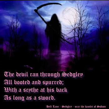 Hell Lane (now Upper Ettingshall Road) had a bad reputation. There was a rhyme about the devil prowling the area and many locals were either involved in the dark arts - or used the idea to scare off others from investigating what they were up to.
 ![]()